 |
measurements 
The
flow- and
turbulence field as well as energy fluxes were measured at a number of surface-sites inside and
around the city of Basel. Two experimental
surface towers were operated over nearly one year in the heavily built-up part of the city
(Ue1 and Ue2).
The
instrumentation was heavily extended during the IOP
between June 15 2002 and July 12 2002. Additional towers were installed in regions of surface structure that is distinctly
different from that at these two main sites, such the 'european suburban'
station in Allschwil (Se1) and ural reference sites
with the full
surface energy balance (Re1, Re2). At the same time,
the flow field in the bulk of the urban boundary layer was continuously monitored
using remote sensing techniques (wind profiler, LIDAR, SODAR, RASS). Finally
a big number of operational and existing
'background stations'
provide more spatially distributed data of the wind- and temperature-field.
 |
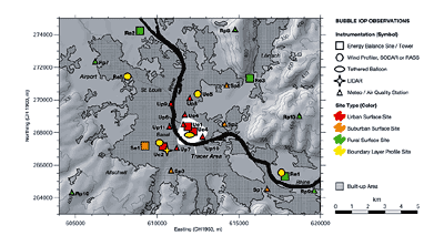
Map of
the measurement stations during BUBBLE-IOP with tracer area
(white). Some rural sites are out of map, see list of
all Stations.
Download map in GIF-format:
Medium (800 x 440): b&w
/ color
Large (1600 x 880): b&w
/ color
Download map in EPS-format: b&w
/ color
|
|
|
 |
Surface
Measurement Sites
 |
List of
all stations |
 |
Basel-Sperrstrasse
(Dense
urban, Ue1) |
 |
Basel-Spalenring
(Dense
urban, Ue2) |
 |
Basel
- Messe
(Urban,
Tethered Balloon, Ue3) |
 |
Basel - Horburg
(Urban
Tracer Release, Ue4) |
 |
Allschwil-Rämelstrasse
(Suburban,
Se1) |
 |
Grenzach
(Rural
Reference, Re1) |
 |
Village
Neuf
(Rural
Reference, Re2) |
 |
Basel -
Lange Erlen
(Rural
Reference, Re3) |
 |
Gempen
(Rural
Reference, Re4) |
|
Instrumentation

|
Measurement
Data
|

|
 |

