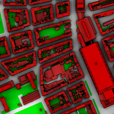
The main urban surface site "Basel-Sperrstrasse" is located in a heavily built-up part of the city ('european urban'). The measurement setup consist of a tower inside a street canyon reaching up to 32 m (2.2zH)
Panorama from the tower at 25m.
(download jpeg-image
including labels) 03.07.2002
Click with mouse down in the image to move around.
Station surrounding. A digital building and tree model is available for a 1 km radius around the site.
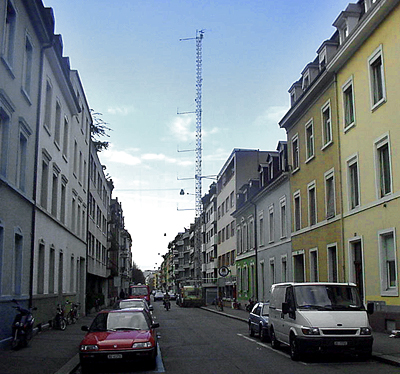
6 levels of sonic anemometers, 6 levels of psychrometers and 12 levels of cup anemometers were operated at the tower. Two full radiation balances, one inside the canyon, and one at 33m were installed. Raw data of the ultrasonic anemometers were sampled continuously with 20.8 / 20 Hz, other data is available at a resolution of 1 min (10 minutes in the database). The tower was built up in October 2001 and was operated until July 2002. There were also a number of activities to investigate Carbon dioxide exchange at Basel-Sperrstrasse
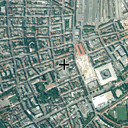 |
Aerial Photo of the station sourrounding approximately 1 x 1 km (Password protected). |
|
|||||||||||||||||||||||||||||||||
|
|||||||||||||||||||||||||||||||||
 |
The
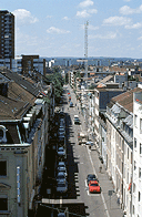
street canyon from above (Sperrstrasse). The orientation of the canyon is
along 67° ENE = 247° WSW. The Photo shows the view from the overpass of the large "Messe Basel"-building east of the site where also the thermal scanner of the UWO an dtracer sampler No 4 were installed. Photographed towards WSW. 8.7.2002. |
||||||||||||||||||||||||||||||||

|
The tower reaches approximately 2.2 times the mean roof height of the urban surface. The shape of the roofs is a mixture of flat and pike roofs. June / July 2002. | ||||||||||||||||||||||||||||||||
 |
The building block section with the tower photographed from SW. The yellow lines indicate the two paths of the scintillometers (read more about the scintillometers on the NUS BUBBLE-website). July 2002. Photo provided by Matthias Roth, NUS. | ||||||||||||||||||||||||||||||||
 |
The yearlong turbulence instrumentation at the tower (labeled Photograph), small large | ||||||||||||||||||||||||||||||||
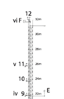 |
Detailed plan
of the tower in pdf-format.
|
||||||||||||||||||||||||||||||||
 |
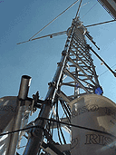
The tower photographed up from inside the canyon. To the right are the radiation component instruments. 6.12.01. | ||||||||||||||||||||||||||||||||
 |
Two LICOR 7500 open path analyzers were coupled with ultrasonic anemometers to investigate carbon dioxide exchange over the city. One was installed at tower top (31.7m) and one at canyon top (14.7m, photo to the left). Read more on air chemistry measurements or on the instrumentaion at the BUBBLE-Website of NUS. July 2002. Photo provided by Matthias Roth, NUS. | ||||||||||||||||||||||||||||||||
 |
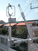
The Gill HS Sonic Anemometer (Level F, 31.7m) at tower top with the LICOR 7500 open path CO2/H2O analyzer and the Krypton KH2O fast hygrometer. Photo provided by Matthias Roth, NUS. | ||||||||||||||||||||||||||||||||
 |
One of the Gill R2 ultrasonic anemometers (22.5m, z/zH~1.5). Photographed towards South. 6.12.01. | ||||||||||||||||||||||||||||||||
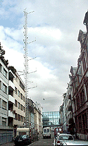 |
The tower viewed from SW towards NE. At tower foot, there is a van for the data aquisition systems. 6.12.01. | ||||||||||||||||||||||||||||||||
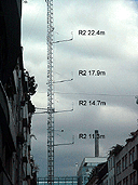 |
Part of the ultrasonic anemometer Profile with instruments B-E (all Gill R2). Photographed towards E. 6.12.01. | ||||||||||||||||||||||||||||||||
 |
Cup anemometer and psychrometer at 22.5m. Photographed towards W. 6.12.01. | ||||||||||||||||||||||||||||||||
 |
Upper part of the profile with 12 cup anemometers and 6 psychrometers. 6.12.01. | ||||||||||||||||||||||||||||||||
 |
Full radiation components are measured once on top (33m) and also inside the canyon. Here, the sysem measuring directly over the street level at a height of 3.2m is shown. Photographed towards E. 6.12.01. | ||||||||||||||||||||||||||||||||
 |
A Kipp & Zonen CM11 inside the Street Canyon at 3.2m (z/zH~0.2). Photographed towards E. 6.12.01. | ||||||||||||||||||||||||||||||||
 |
An additional Pyranometer (CM11) below rooftop at 12.4m (z/zH~0.8). Photographed towards E. 6.12.01. | ||||||||||||||||||||||||||||||||
 |
Fisheye
view of the downward-looking radiation instruments at tower top.
June 2002. Photo provided by Geoff Doerksen, UBC |
 |
During the IOP a number of tracer release experiments were carried out. During all experiments the tower was equipped with a profile of six samples at 3 heights. 26.6.2002. |
 |
Results from a physical model in the wind tunnel at University of Hamburg are expected to complement and help the interpretation of the full scale measurements. |
