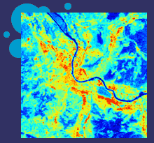
 With
in situ measurements at surface stations the radiation balance can only be
measured for point locations and not over the whole urban area. But
measurements of net radiation and heat fluxes suffer from the extreme
heterogeneity of the urban landscape. One solution is the application of
satellite remote sensing in combination with numerical models. Especially
the thermal remote sensing of surface temperatures and the combination of
this with the in situ measured data is important.
The project BUBBLE-SARAH (Satellite
Analysis of Radiation And Heat Fluxes
A first aim of BUBBLE-SARAH is to compute the spatially distributed net
radiation as a key factor for heat flux studies. Shortwave reflection and
longwave emission can be computed from multi-spectral satellite data. In
the meantime there a several satellite platform available which offer a
very promising spatial resolution like LANDSAT-7-ETM+ and ASTER (Advanced
Spaceborne Thermal Emission and Reflection Radiometer). Depending on the
successful launch of the European ENVISAT satellite it is also planned to
try to use ENVISAT data for the analysis. The most interesting sensors of
ENVISAT for this study are MERIS (Medium resolution imaging Spectrometer)
which measures radiation in 15 frequency bands, ASAR (Advanced synthetic
aperture Radar) and AATSR (Advanced along track scanning radiometer).
In addition to these high resolution sensors it is planned also to
analyse NOAA-AVHRR and MODIS data which have a poor spatial resolution of
1000 m only, but offer a fairly good temporal resolution of several orbits
per day to cover the diurnal variations of surface temperature
distribution.