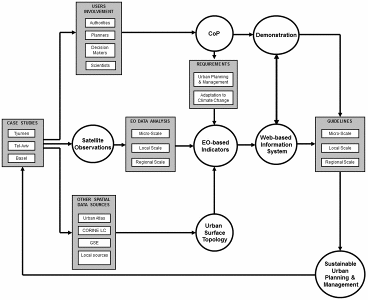
Fig. 1: Flowchart of the GEOURBAN methodology
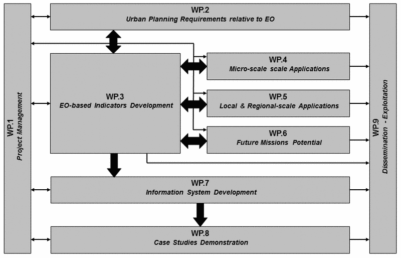
Fig. 2: Workpackage components and their interdependencies
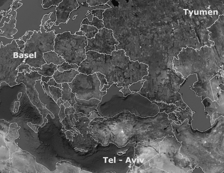
Fig. 3: The geographic distribution of GEOURBAN case studies
|
GEOURBAN: ExploitinG Earth Observation in sUstainable uRBan plAnning & maNagementProject summarySustainable urban planning and management increasingly demands innovative concepts and techniques to obtain up-to-date and area-wide information on the characteristics and development of the urban system. The increasing availability of Earth Observation (EO) technologies has provided new opportunities for a wide range of urban applications, such as mapping and monitoring of the urban environment, socio-economic estimations, characterization of urban climate, analysis of regional and global impacts and urban security and emergency preparedness. However, a gap exists between the research-focused results offered by the urban EO community and the application of these data and products by urban planners and decision makers. Recently, however, increasing attention is being directed to bridge this gap. To this end, the main objective of the GEOURBAN (ExploitinG Earth Observation in sUstainable uRBan plAnning & maNagement) project is to bridge the gap between EO scientists and urban planners by demonstrating the ability of current and future EO systems to depict parameters of urban structure and urban environmental quality over large areas at detailed level. The innovative potential of the project lies in the development of a web-based information system which reflects the multidimensional nature of urban planning and management, as operationalized in intelligible and transferable indicators which are easily understood and applicable by a non-scientific public. Three cities with different typologies and planning perspectives are included as case studies: Tyumen (Russia), Tel-Aviv (Israel) and Basel (Switzerland). In order to develop a method that will be welcomed by local governments, the project will use a Community of Practice (CoP) approach, which means that in the case studies, local stakeholders and scientists of the GEOURBAN project will meet on a regular basis in order to learn from each other. One of the main purposes of the CoP is to acknowledge the different stakeholders' perceptions into the indicator development. The EO data is the main input for GEOURBAN indicators. State-of-the-art EO analysis methods will be used to calculate products from raw data. The information system will be developed in an iterative procedure. User requirements will lead to EO-based indicators, as well as to specifications for the system design. The consortium will release several versions of the system during its development exercise. Since it will be a web-based tool, the end-users will be able to evaluate it online and provide their feedback. The consortium will take into account the end-user suggestions to develop the next version of the system. The final version will be available during the demonstration event to be organized by the end of the project. The work to be carried out has been broken down into nine Work Packages (WPs) following the logical phases of the implementation of the project. There are two horizontal WPs (WP1: Management and WP9: Dissemination - Exploitation) and seven thematic WPs: WP2 specifies the urban planning and management requirements, providing guidelines to the other WPs. The EO-based indicators will be developed in WP3, taking into account these guidelines. The EO data will be analysed in WPs 4 and 5, whereas the capabilities of future missions will be explored in WP6. WPs 4, 5 and 6 will give inputs to WP3. The indicators that will be developed in WP3 will be integrated in the system to be developed in WP7. Finally, WP8 is dedicated to information system demonstration. Since the adaptation of the system to future missions will be addressed, it is expected that a fully operational tool can be developed in the future. However, new services based on the GEOURBAN pre-operational information system can be developed for the urban planning and management community, as soon as this system is available. MCR contributionWorkpackage leader WP2 (urban planning requirements relative to EO)
1st CoP meeting, 25 April 2012 (program) presentations: Chrysoulakis, GEOURBAN introduction Feigenwinter, meeting objectives Chrysoulakis, Communities of Practice Parlow, The potential of EO data to support urban planning Sandtner, Die Rolle von Geo-Daten in der Praxis Prudent, A GIS platform for a cross-border planning area GEOURBAN project organisationproject leader:Foundation for Research and Technology, Hellas, Greece (FORTH) project parnters: GRAD Inform Ltd., Russia (GRADI) GARD Ltd., Tel Aviv, Israel (GARD) Deutsches Zentrum für Luft- und Ramfahrt, Germany (DLR) Kuzgun Bilisim, Turkey (KUZGUN) MCR Lab, University of Basel, Switzerland (UNIBAS) ContactLinks |