
Fig. 1: Topography of the Meteor Crater region.

Fig. 2: Meteor Crater, looking southwest
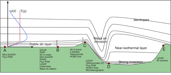
Fig. 3: Conceptual model for warm air intrusions ...
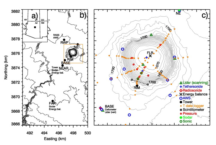
Fig. 4: Map of Meteor Crater and vicinity, ...

Fig. 5: Initial simulation of the formation of a DWF in the Meteor Crater.
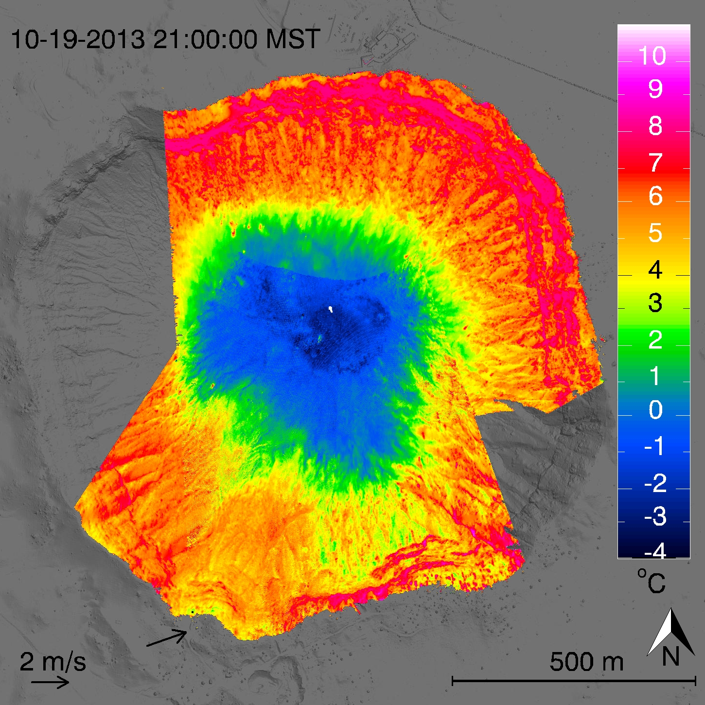
Fig. 6: Surface temperature distribution in the Meteor Crater recorded by three TIR cameras.
|
METCRAX II: The second Meteor Crater ExperimentContribution of the University of BaselDuring three intensive observational periods (IOPs) of METCRAX II, three thermal infrared (TIR) cameras pointed into the crater from different perspectives recording surface temperatures (Fig. 6). The research group for meteorology, climatology and remote sensing (MCR) from the University of Basel together with the University of Bochum carried out TIR time lapse observations and analyzed the resulting data. The TIR data has been georeferenced with the FOV geometry of the cameras and time lapse movies in 30 min intervals have been produced. Movies and further information are available in the Infrared Thermography section. Map of the Meteor CraterFor further Google Earth imagery (2- and 3-D images of the Meteor Crater) kindly use the following coordinates: 35°01′38.92″ N 111°01′20.24″ W Barringer Meteor Crater and other linksMETCRAX II official homepage, University of Utah Project summary compiled from the METCRAX II official homepage, University of UtahA 4-yr research program has been designed to follow-up on a serendipitous discovery that we made in prior experiments (METCRAX I) conducted at Arizona's Meteor Crater. Arizona's Barringer Meteorite Crater (AKA Meteor Crater) is a nearly ideal axisymmetric basin formed by the impact of a meteorite 49,000 years ago (Kring 2007). The bowl-shaped crater, 175 m deep and 1.2 km in diameter, is located on a plain (Fig. 1) that is tilted up slightly (1° angle) to the southwest toward Arizona's Mogollon Rim. The crater rim, unbroken by any major passes or saddles, extends 30-50 m above the surrounding plain. The crater floor elevation is 1563 m MSL. A photograph of the crater is provided in Figure 2. During experiments conducted in Meteor Crater on clear, light-background-wind nights in October 2006, we experienced occasional unusual meteorological events on the west sidewall of the crater. There, short-lived high wind and turbulence events occurred, while other sites within the crater were completely unaffected. These downslope-windstorm-type flows (DWFs) were confined to the immediate lee of the upwind rim of the crater, and many such events occurred during the one-month observational period. The temporary and often short-lived instability leading to these discrete events is apparently produced by changes in the vertical temperature or wind structure in the regional-scale drainage flow that impinges on the crater's rim from the terrain southwest of the crater. This drainage flow has a jet maximum and an inversion height that correspond roughly to the height of the crater rim above the adjacent plain. This site thus provides an unusual opportunity to investigate the sensitivity of DWFs in a stably stratified atmosphere to temporal changes in the ambient approach flow structure. The flow over the crater rim appears similar to that of hydraulic flows over obstacles in stream channels, and is thought to include the development of a hydraulic jump in the lee of the crater's ridge (Fig. 3). We have used this fortuitous topographic/meteorological situation to design a field experiment and modeling program to systematically study this 'katabatically driven hydraulic flow' phenomenon in a natural setting. This has not been possible before and has the potential to greatly improve understanding of analogous atmospheric flows such as those that occur in Bora, Foehn and Chinook windstorm events, and in cascades of air over passes and through gaps and channels. Potential benefits of the project include improved understanding, analysis, and prediction of atmospheric flows leading to downslope windstorm-type events, which have many important societal impacts. The nighttime mesoscale drainage flow approaches the crater from the southwest. The meteorological measurements will come from 5 experimental locations, as indicated in Fig. 3 on a southwest to northeast cross section. The five sites are described as follows:
|
Research QuestionsThe research is designed to answer several scientific questions about atmospheric downslope-wind-type flows that form in stratified airflow over topographic ridges. Scientific questions include:
NSF proposalFurther detailed information on the project can be found in our National Science Foundation proposal. The Fall 2013 field programThe goal of the fall 2013 field experiments is to answer the scientific questions posed above by designing a laboratory-like experiment where the approach flow is carefully monitored along with the atmospheric response inside the crater. The data will be used to support detailed meteorological analyses to fully characterize these events and to develop and test conceptual and atmospheric numerical models regarding their causes and the role of changes in the approach flow that affect their evolution. The actual locations of the sites where equipment was located in the Fall 2013 experiment are shown in Figure 4 below. These sites follow the general plan given above (i.e., Sites A through E), except that logistics considerations (communications, cell phone coverage, radio interference of RASSes, access to roads, etc.) required adjustments to the locations of some of the sites. The modeling programNumerical simulations of the flow over the Meteor Crater have already been performed in advance of the field experiments to assist in the location of meteorological instruments for the Fall 2013 field experiments. Those simulations have been used as input to make a series of simulations of the lidar volume that will be scanned by the Site D and E lidars to assist in interpreting field data and to gain further knowledge about the downslope-windstorm-type flows. Idealized two-dimensional (2-D) and three-dimensional (3-D) simulations will be performed for the Meteor Crater. The idealized setup will allow us to control the upstream and in-crater conditions (i.e. stability and winds) and, thus, to determine the conditions necessary for the formation of DWFs in the lee of the crater rim. We will focus on the controlling parameters individually, changing one parameter at a time, to determine the respective change in the flow regimes. A simple initial simulation of the flow over the Meteor Crater is shown in Figure 5. With the comparison of 2-D and 3-D simulations we will examine whether the DWFs can be described adequately by simple 2-D flow over a ridge. The circular crater topography most likely produces 3-D phenomena, such as flow splitting around the crater in contrast to a blocking of the flow by the crater rim, which may affect or determine the resultant flow regime. We will investigate the upstream and in-crater atmospheric conditions systematically in a parametric study where individual parameters will be systematically varied to determine their influences on the flow. These simulations will be guided by the field observations and thus will be focused on those parameters that can be identified in the observations as controlling the formation of hydraulic jumps. Based on the data from the previous field campaign at Meteor Crater, upstream temperature conditions are likely to include (i) the depth of the surface inversion that forms on the sloping plain outside the crater, (ii) the inversion strength, (iii) the absolute temperature difference between the air that comes over the rim and the air inside the crater, and (iv) the temperature profile of the stagnant air that pools up ahead of the crater rim in contrast to the temperature profile further upstream. Upstream wind parameters may include (v) the height of the jet in the drainage flow with respect to the rim height, (vi) the jet depth with respect to the rim height, (vii) jet strength, (viii) wind shear at the height of the rim, and (ix) the possible deformation or lifting of the drainage flow by the cold-air pool upstream of the crater rim. In-crater conditions may include (x) the stability of the crater atmosphere, and (xi) capping inversions on top of the crater atmosphere. Model simulations will be used to evaluate the effect of the unique crater topography and to generalize the findings from Meteor Crater. The spatial scale of Meteor Crater is small compared to most locations where severe downslope windstorms and atmospheric hydraulic jumps have been observed. Furthermore, the crater is strongly asymmetric, with a height of 30-50 m above the surrounding plain and a depth of 175 m above the crater floor. Thus, an important question to be answered is how the results from Meteor Crater can be scaled to larger topography and applied to ridges with different ratios of upstream ridge height to downstream ridge height. |
Thermal infrared team - IR time lapse cameras:
For further personal see the official page |
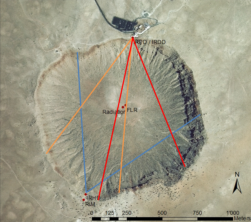
Fig. 1: Position of the three TIR cameras
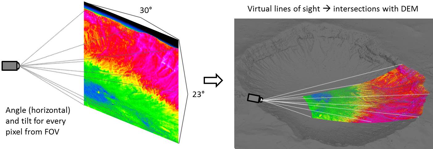
Fig. 2: Scheme of projecting the 2D TIR image ...
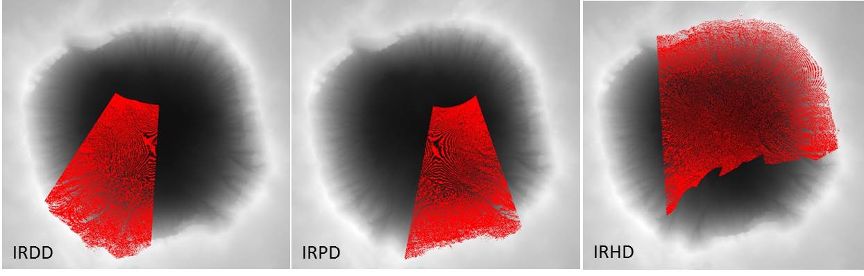
Fig. 3: Intersections of the TIR pixels ...
Movies by IOPIOP2 (12.10.2013)IOP3 (17.10.2013)IOP4 (20.10.2013) |
Thermal infrared imaging during METCRAX IIThe location and the FOV of the three TIR cameras which recorded the surface temperature of the crater during METCRAX II is shown in Fig. 1. Two VarioCAM hr research 600 (here called IRDD and IRPD) were installed at the north rim on the terrace of the museum and recorded the southern sidewall of the crater. Only during IOP4 a third camera (IRHD) located on the south rim looking to NNE recorded the northern sidewall of the crater. A georeferencing of the TIR data has been performed by drawing virtual lines of sights for every pixel to find intersections with a high resolution digital elevation model of the crater (Fig. 2). The intersections for each camera are shown in Fig. 3. The georeferenced pixels have been used to make a comparison between a reference radiation measurement (CG4, Kipp and Zonen) located on the crater floor and the TIR data. Examples of TIR movies are shown below and can be selected by IOP and time on the left hand side. For more information about the georeferencing or for further TIR movies please contact Iris Feigenwinter Research questions
(Looped) Thermal infrared time-lapse moviesThe left column shows spatiotemporal fluctuations of the TIR data calculated after a decomposition primarily developed by Vogt (2008) to visualize turbulence. On the right hand side in color absolute surface temperatures are shown. The movies are from two different perspectives. The upper ones are looking from bird's eye perspective onto the crater showing the georeferenced TIR pixels while the lower movies are the two images from the north rim cameras combined that look from NNE to SSW. Arrows indicate the wind speed and wind direction from the rim and crater floor station. The intermittently rising and descending points on the sidewalls are tethersondes that measured vertical profiles of different meteorological variables in 15 min intervals. Hint: Should the videos not be playing in sync, use the "Reset Playback" button in the menu on the left. Video: Exemplary TIR temperature videos of a top and side view of the absolute values and fluctuations within the crater.
|
Journal articles (reverse chronological order):Lehner, M., C. D. Whiteman, S. W. Hoch, E. T. Crosman, M. E. Jeglum, N. W. Cherukuru, R. Calhoun, B. Adler, N. Kalthoff, R. Rotunno, T. W. Horst, S. Semmer, W. O. J. Brown, R. Vogt, M. Grudzielanek, J. Cermak, C. Bernhofer, Mathias Krausz, and P. Klein, 2014: The METCRAX II field experiment - A study of downslope-windstorm-type flows in Arizona's Meteor Crater. Bull. Amer. Meteor. Soc. Submitted. Presentations with personnel involved at the University of BaselFeigenwinter, I., R. Vogt, M. Müller, E. Parlow, M. Grudzielanek, M. Maric, C. D. Whiteman, M. Lehner, S. W. Hoch, 2015: Visualization of high-resolution surface temperature data in Barringer Meteor Crater during METCRAX II. 33rd International Conference on Alpine Meteorology, Innsbruck, Austria, 31 August-4 September 2015 (poster). Grudzielanek, M., R. Vogt, J. Cermak, I. Feigenwinter, M. Maric, C. D. Whiteman, M. Lehner, S. W. Hoch, M. G. Krausz, C. Bernhofer, and J. Pitacco, 2015: Infrared imaging for air flow analyses in the Barringer Meteor Crater, Arizona, as part of METCRAX II. 33rd International Conference on Alpine Meteorology, Innsbruck, Austria, 31 August-4 September 2015 (poster). Maric, M., M. Grudzielanek, R. Vogt, J. Cermak, I. Feigenwinter, C. D. Whiteman, M. Lehner, and S. W. Hoch, 2015: Evaluation of infrared imaging for measuring near-ground flow dynamics at the Barringer Meteor Crater as part of METCRAX II. 33rd International Conference on Alpine Meteorology, Innsbruck, Austria, 31 August-4 September 2015 (poster). Whiteman, C. D., M. Lehner, S. W. Hoch, M. O. G. Hills, N. Kalthoff, B. Adler, R. Rotunno, R. Vogt, I. Feigenwinter, M. Grudzielanek, J. Cermak, T. Haiden, N. W. Cherukuru, and R. Calhoun, 2015: The second Meteor Crater Experiment (METCRAX II): Introduction and overview of recent results. 33rd International Conference on Alpine Meteorology, Innsbruck, Austria, 31 August-4 September 2015 (oral). Grudzielanek, M., R. Vogt, J. Cermak, I. Feigenwinter, M. Krausz, C. Bernhofer, A. Pitacco, C. D. Whiteman, M. Lehner, and S. W. Hoch, 2014: Thermography analysis of air flow dynamics in the Barringer Meteor Crater, Arizona, as part of the second Meteor Crater Experiment (METCRAX II) in October 2013. 16th Amer. Meteor. Soc. Conf. on Mtn Meteor., San Diego, CA, 18-22 August 2014. PDF Whiteman, C. D. M. Lehner, S. W. Hoch, E. Crosman, M. Jeglum, N. W. Cherukuru, R. Calhoun, T. W. Horst, W. O. J. Brown, S. Semmer, R. Rotunno, N. Kalthoff, B. Adler, R. Vogt, and M. Grudzielanek, 2014: The second Meteor Crater Experiment (METCRAX II) - An overview of the October 2013 field study. 16th Amer. Meteor. Soc. Conf. on Mtn Meteor., San Diego, CA, 18-22 August 2014. PDF Grudzielanek, M., R. Vogt and J. Cermak, 2014: Analysis of katabatic flow using infrared imaging at micro- and mesoscale, 21st Symposium on Boundary Layers and Turbulence, Leeds, U. K., 9-13 June 2014. PDF Whiteman, C. D., S. Hoch, M. Lehner, A. Charland, M. Jeglum, R. Rotunno, T. Horst, S. Semmer, B. Brown, R. Calhoun, N. Kalthoff, B. Adler, and R. Vogt, 2013: METCRAX II - An upcoming field investigation of downslope-windstorm-type flows on the inner sidewall of Arizona's Meteor Crater. 32nd International Conference on Alpine Meteorology, 3-7 June 2013, Kranjska Gora, Slovenia. Other presentations |