![]()
Classification of Areal Types
The data layers for the areal percentages of the applied pixel classes (PCs) serve as input data into a rule-based classifier (RBC), which was originally developed in the KABA-project for the retrieval of the areal types (ATs) and modified for the purposes of CAMPAS.
While PCs correspond to different land-cover types of specific electromagnetic characteristics, the ATs describe different land-use classes urban and regional planners are dealing with. They therefore display a functional as well as a physiognomic character. The AT 'commercial and industrial areas' always includes, according to its definition, a certain amount of the PC 'commercial and industrial buildings' but, in most cases, it is also composed of variable portions of other PCs like 'asphalt and concrete surfaces', 'rails', 'greens' or in case of a harbor with water surfaces.
Table 1 shows ten different areal types classified for the study site. Rules of the RBC are based on:
![]() the majority of the pixel class dominating a
certain areal type (e.g. forests)
the majority of the pixel class dominating a
certain areal type (e.g. forests)
![]() the combination of a set of various areal
percentages of different pixel classes
(e.g. commercial and industrial areas, urban centers).
the combination of a set of various areal
percentages of different pixel classes
(e.g. commercial and industrial areas, urban centers).
Tab.1: Areal types used in CAMPAS.
| No. | Code | Colour | Areal type (AT) | Rules of the classifier |
| 1 | Ws |
|
Waters | (psettlements< 50% and
pWs ³ pTr
and pWs ³ (pAG + pGG)) or pWs ³ 25% |
| 2 | Fo |
|
Forests | psettlements< 50% and pTr ³
pWs and pTr ³ (pAG+ pGG) |
| 3 | GFG |
|
Grassland, farmland and greens | psettlements< 50% |
| 4 | ETA |
|
Extended traffic areas | ptraffic³ 0.5·psettlements |
| 5 | CI |
|
Commercial/industrial areas | (pCI+pvB+ptraffic)³
0.5·psettlements and pCI ³ pvB and pCI ³ ptraffic |
| 6 | lDS |
|
Low-density settlements | phousing ³ 0.5·psettlements and plB ³ 0.5·phousing |
| 7 | mDS |
|
Medium-density settlements | phousing ³ 0.5·psettlements |
| 8 | hDS |
|
High-density settlements | phousing ³ 0.5·psettlements and phB ³ 0.5·phousing |
| 9 | UC |
|
Urban centers | psettlements ³ 80% and pvB ³ 0.5·psettlements |
| 10 | SMS |
|
Settlements of mixed structure | remaining areas |
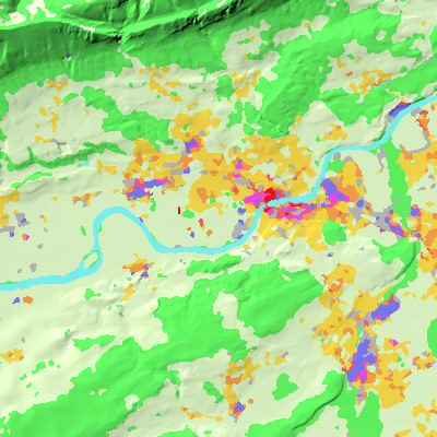
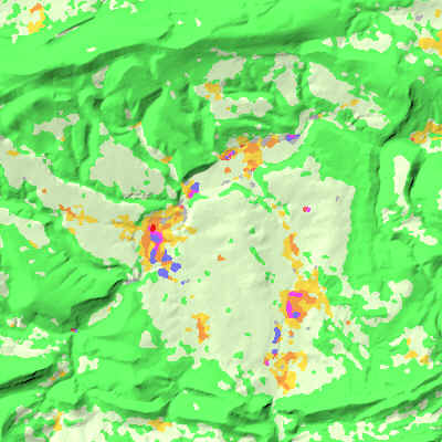
Results of the classification including consideration of spatial context are shown in figures 1 to 4 providing some examples of the Canton Solothurn with a resolution of 25 m.
 |
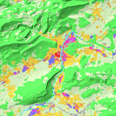 |
| Fig. 1: The city of Solothurn and surroundings. | Fig. 2: The city of Olten and surroundings. |
 |
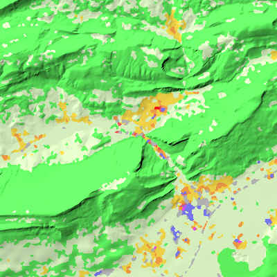 |
| Fig. 3: The basin of Laufen. | Fig. 4: The city of Balsthal and surroundings. |
![]()
![]()
![]()