
Kärkevagge Field Campaign 1995 (KV'95)
Kärkevagge Field Campaign 1995 (KV'95)
During the Kärkevagge field campaign 1995 the Kärkevagge hut was the base camp. Most of the transportation had to be done by helicopter flights.
The studies were focused on the Kärkerieppe cirque on the eastern slope of
Mt. Vassitjåkko. This valley is identified as a preferable slush torrent site, well
documented by a broad sediment fan at its outlet.
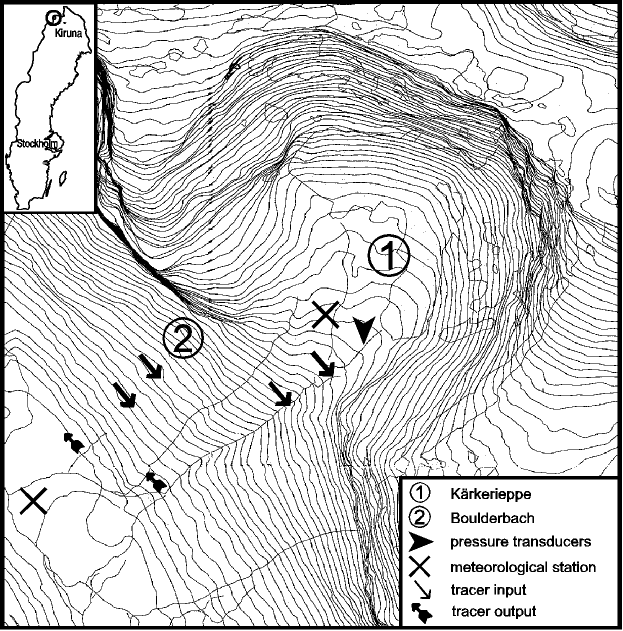
The Kärkerieppe cirque is characterized by steep slopes of appr. 400 m height, a
cirque bottom with slopes of 6 to 12° towards the outlet and some relics of moraines.
Parts of the inner cirque are covered by firn. The drainage system has two branches in the
cirque area, divided by moraine ridges. In the upper part of the slope, discharge is not
channeled but overland flow is widespread. Only in the lower third of the slope a channel
concentrates the flow through a boulder field.
The objectives of the investigations required a twofold methodology. On the one hand, meltwater production had to be monitored by meteorological measurements. On the other hand, meltwater movements and the formation of an inclined water table within the snow cover had to be measured.
Meteorological measurements:
The measurements comprised standard meteorological variables like global radiation, air
temperature, humidity, wind, air pressure and precipitation, but also a complete and
accurate determination of the energy balance components. Two stations were installed, one
at the valley bottom (Valley Station) and the other in the
cirque area (Cirque Station). Both stations were equipped with
sensors allowing a complete determination of the energy balance components. At the valley
station, a redundant but direct measurement of the turbulent heat fluxes with high
accuracy was carried out by an eddy-covariance system.
Snow hydrological measurements:
Snow hydrology is investigated by measuring volume and velocity of meltwater movements
within the snow, by monitoring saturation of the snow cover, and finally by observing snow
metamorphism in pits. The hydrological investigations are
concentrated on the measurements of meltwater drainage of the snow cover in drainage
channels and on straight slopes. For this purpose, different fluorescence dye tracers were
injected at the base of the snow e.g. in the upper Kärkerieppe channel. Samples were
taken automatically in constant time intervals in the lower parts of the channel and
analysed with a field fluorometer.
Meltwater accumulation and the formation of a water table within the snow cover were
monitored by two pressure transducers, installed on the base of the gently inclined
drainage channel of the northern part of the Kärkerieppe, close to the beginning of the
steep main drainage channel. Additionally, conductivity meters were installed at the same
places to prove that not the matrix pressure of the snow but the water level is measured.
In the snow pits, snow stratigraphy, temperatures, crystal shapes, and further, meltwater
accumulation and movements were registered.
During the snowmelt period in 1995, the temperature measurements
revealed a rise to isothermal snow conditions around the 20th of May, starting in the
lower areas and showing a delay of a few days in the upper test site. First signals of
basal meltwater accumulations could be observed on May 26th in a snow pit in the
Kärkerieppe. Ground infiltration dominated in the beginning, until two days later the
first lateral meltwater flow was registered in the pits.
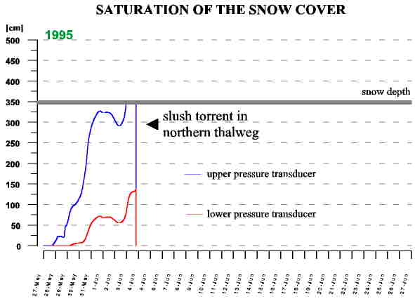
The meltwater production on the Kärkerieppe slopes and the developing drainage system
within the snow cover resulted in an increasing input of water to the valley bottom. On
the other hand, meltwater output from the Kärkerieppe through the snow-filled channel was
limited. This led to an accumulation of meltwater, visible by a blueish snow field of
appr. 150 m length and 10 to 20 m width on the northern branch of the drainage system.
Also the two pressure transducers measured this development: the upper one exceeded its
maximum measurement range of 2.5 m since May 30th, while the lower one monitored the
increasing water table until it reached appr. 1.5 m prior the slush torrent release, as
you can see on the following figure.
In the evening of the 3rd of June the fluvial drainage system was
already developed in some parts of the Kärkerieppe drainage basin, mainly initiated by
small slushflows. But in the northern parts no open drainage channels could be observed.
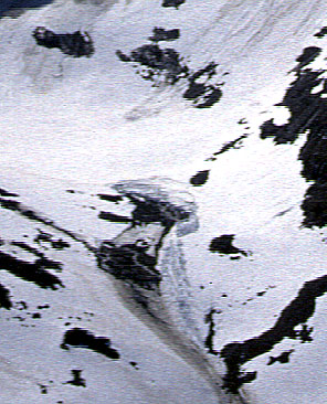
At 19:19 CEST, meltwater accumulation suddenly disappeared in that area. A few seconds
later, a system of cracks in the snow cover developed,
starting at the downslope side and forming a horseshoe-like
structure at the upper end of the former saturation zone. Subsequently, a slush
torrent started as a strongly accelerating movement of snow and water. The main mass
movement took place in several pulses that incorporated more and more water and snow from
upslope. The total volume of removed snow and water amounts at least 10000 m3,
and at least 150 t of sediment were mobilized by the event.
The slush torrent was well documented in 1995. There is a series of photographs of the
movement downslope and a video of the slush torrent in its release zone.
Three pictures of the slush in action. Note the splashing wave at the end of the canyon
with a height of more than 10 m in the second picture.
There is a computer-generated animation as mpeg-movie (5MB !!!) based on the photographs of the first 45 seconds of the slush torrent.
In addition, a video could be taken in the Kärkerieppe cirque showing the release of the slush torrent including the huge water wave that formed the second pulse. The video is also available as mpeg-movie (11 MB !!!).
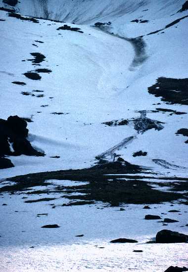
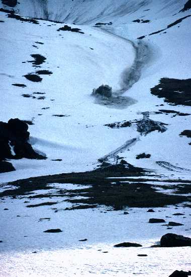
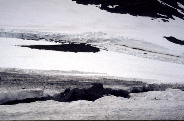
After several days, the release zone was save to visit.
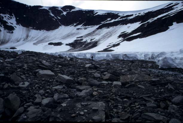 The release zone, view inside
the cirque. Note that avalanches did not reach the release zone.
The release zone, view inside
the cirque. Note that avalanches did not reach the release zone.
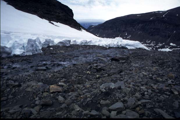 The release zone, view
outside the cirque. A small creek has developed.
The release zone, view
outside the cirque. A small creek has developed.
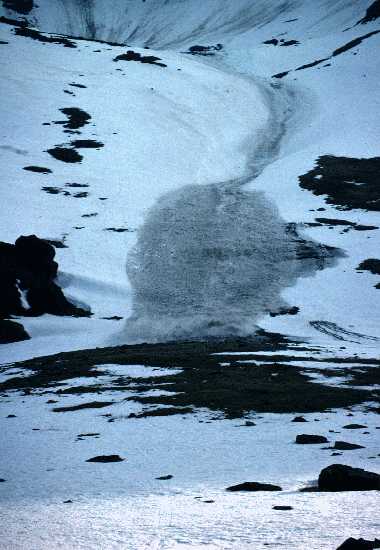
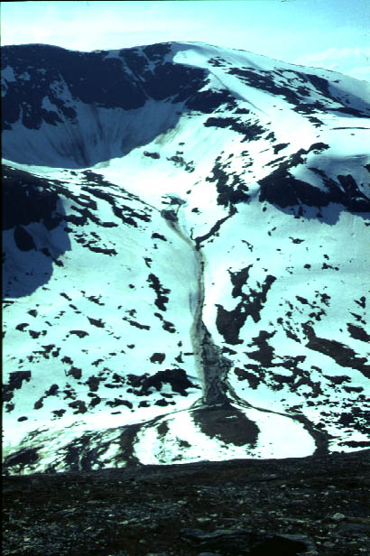 Photograph of the Kärkerieppe slush torrent track.
Slush torrents may be released even if no extreme meteorological conditions are present, as they were observed in the Liefdefjord region in Svalbard in June 1992. Energy input by net radiation and positive temperatures in the normal range of situations with warm air advection may be sufficient for meltwater production rates that can cause even major events.
The hydraulic pressure gradient has to be regarded as the most important factor in slushflow initiation. This explains the clear distinction between slushflows and snow avalanches. In addition, external trigger processes as wet snow avalanches are not prerequisite to slush torrent initiation.
Permafrost, an effective inhibitor for infiltration losses of meltwater during snowmelt, is not a precondition for slush torrents
We want to express our thanks to all persons, who had helped us to gain these results. In particular, D. Barsch and E. Parlow made this field campaign possible by their significant contribution and support. Many thanks are given to G. Bing, M. Gempeler, T. Löschmann and G. Schukraft, who worked with us in the field. We extend our thanks to all members of the Abisko Scientific Research Station, who supported us gratefully. Special thanks are due to A. Rapp for his scientific advice and his previous works. P. Schlyter from Lund University is said thanks for his scientific and logistic cooperation. The Dept. of Geography of the ETH Zürich had supported our campaign logistically, for which we want to thank. This field campaign was financed by the Swiss Academy of Sciences.
· Top
of page · MOSAIC home·
 KV home