![]()
Classification of Ventilation Situations
Ventilation situations are numerical representatives of areas with specific combinations of terrain or land-cover parameters controlling wind fields and horizontal or vertical air mass exchange processes.
Areas classified for a certain ventilation situation show an increased probability for the occurrence of specific meteorological processes e.g. for reduced horizontal air mass exchange and hence higher concentrations of air pollutants in densely built-up areas (areas of reduced ventilation). There is a physical basis behind the concept of ventilation situations existing, but one should keep in mind that per definition they posses a climatological, i.e. statistical nature. For detailed information on ventilation situations as well as the methodology see publication list: Fehrenbach (1999), Scherer et al. (1999).
Tab.1: Ventilation situations used in CAMPAS.
| No. | Color | Ventilation situation (PV)/classes (VC) | Brief description |
| 1 |
|
Indifferent areas* | No specific modification of wind fields. |
| 2 |
|
Wind-exposed areas | Increased probability of higher wind speeds due to exposed topographic situations. |
| 3 |
|
Terrain-induced ventilation paths | Channeled flow along valley axis due to drainage flows from upslope areas or by topographic modifications of synoptic winds. |
| 4 |
|
Terrain-induced ventilation on slopes | Slope winds along gradient lines. Partly deflection of synoptic winds. |
| 5 |
|
Areas of undisturbed ventilation | Undisturbed flow due to small surface roughness. |
| 6 |
|
Areas of reduced ventilation | Modified flow of air masses due to massive flow obstacles. |
| 7 |
|
Cold-air accumulation areas | Reduced wind speed and strong stratification due to cold-air accumulation in hollows or by barrier effects caused by valley narrows and settlement structures. |
Two different terms have to be discriminated looking at the concept of ventilation conditions:
Potential ventilation situations (PV) are computed for each pixel by criteria depending on land-use and terrain features for each clearly defined ventilation situation (table 1 PV 2 - 7). Rule-based classification results in six binary data layers (one for each PV). A pixel may, according to its structural settings, belong to more than one PV.
However different ventilation situations are connected to different problems which have to be considered in urban and regional planning. For this reason one has to assign a certain priority to each PV according to their degree of relevance for planning affairs. After setting these priorities we are talking about ventilation classes (VC; only one for each pixel). As long as only one PV is classified for a pixel, PV and VC are identical. Indifferent areas do not fit to any of the chosen classification criteria of the PVs.
Spatial context is considered by area in- and exclusion for each individual PV. There was no further generalization of the distribution of the VCs due to the preservation of the spatial context of the PVs in the intersected VC layer.
PVs are used together with the areal types as input data in the numerical models for the retrieval of the planning guidelines in phase 2.
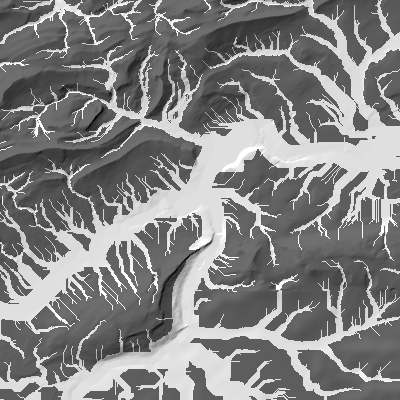
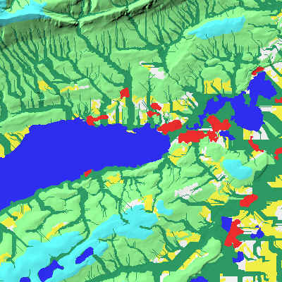
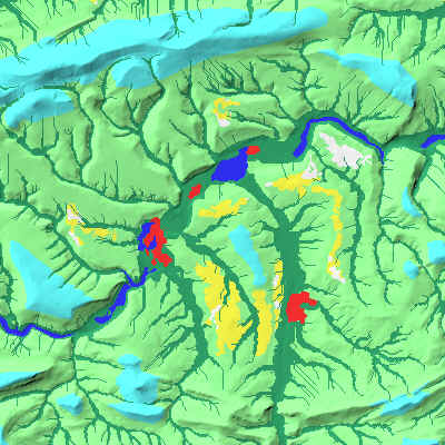
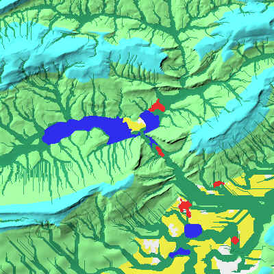
While figure 1 demonstrates the distribution of two PVs, figures 2 - 5 provide some examples showing the final spatial distribution of ventilation classes (color coding see table 1) with a resolution of 25 m.
 |
 |
|
Fig. 1: Ventilation situations 'Terrain induced ventilation paths' (left) and 'Areas of cold-air accumulation' (right) in the city of Olten and surroundings. |
|
 |
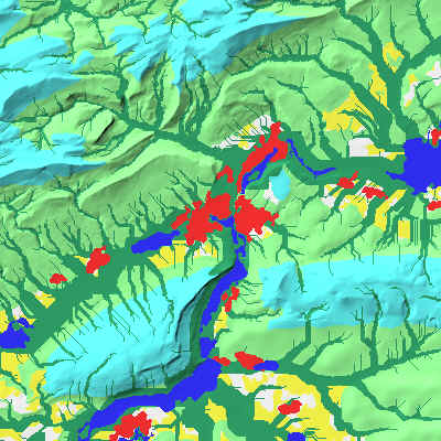 |
| Fig. 2: The city of Solothurn and surroundings. | Fig. 3: The city of Olten and surroundings. |
 |
 |
| Fig. 4: The basin of Laufen. | Fig. 5: The city of Balsthal and surroundings. |
![]()
![]()
![]()